DCS Airspace is a free, web-based real-time ATC, AWACS, and GCI
software client for DCS World, developed as part of the Combined Ops
suite. It provides a realistic radar and airspace-control workstation
for controllers and tactical operators, with the functions required to
monitor, identify, coordinate, and control air traffic and tactical
airspace during multiplayer missions.
Its realism is based on fidelity to the DCS World simulation:
DCS Airspace does not attempt to recreate the real world independently,
but provides controllers with an operational interface built around
the data and behavior generated by the DCS simulation itself.
The system provides a shared real-time tactical picture for
air traffic control, airspace management, airborne surveillance,
ground-controlled interception, and tactical coordination.
Controllers can manage aircraft, flights, approaches, tracks,
airspace, and engagements from a single browser-based interface.
DCS Airspace connects to DCS World through DCS Olympus and can
use operational mission data from DCS AOC Tools and
DCS Mission Planner, allowing the controller's tactical picture
to be integrated with the wider Combined Ops mission-planning workflow.
DCS Airspace brings mission, flight, and airspace information together
in a single operational interface. It can display data from
DCS AOC Tools and DCS Mission Planner, including
Air Tasking Orders (ATO), Airspace Control Orders (ACO), SPINS
(Special Instructions), Communication Plans (Commplans), flight plans,
and mission information. This allows ATC, AWACS, GCI operators,
pilots, and squadron staff to work from the same operational
information during a DCS World mission.
The interface provides real-time information about the mission
environment while keeping commonly used airspace and tactical data
immediately available to controllers. Operators can monitor aircraft
activity, manage tracks and flights, coordinate traffic and airspace,
review operational data, and perform tactical control tasks without
leaving the same workstation. Keyboard shortcuts are also supported
for actions that need to be performed quickly during a live mission.
Why does DCS Airspace use the DCS Olympus server?
DCS Airspace uses DCS Olympus to communicate with the DCS World
server and obtain the live simulation data required for its real-time
airspace picture. The architecture provides the external ATC, AWACS,
and GCI interface while keeping the additional processing required on
the DCS World server as low as possible. This helps maintain a
responsive DCS World mission while providing controllers with the live
information required for realistic airspace control and tactical
operations.
Another advantage is that DCS Olympus is already used by many virtual
squadrons and DCS World communities as part of their server
infrastructure. DCS Airspace can therefore use an existing DCS Olympus
server instead of requiring the installation and operation of a
separate dedicated server component. This simplifies deployment and
avoids adding another server-side application and additional workload
to the DCS World server environment.
DCS Airspace main features
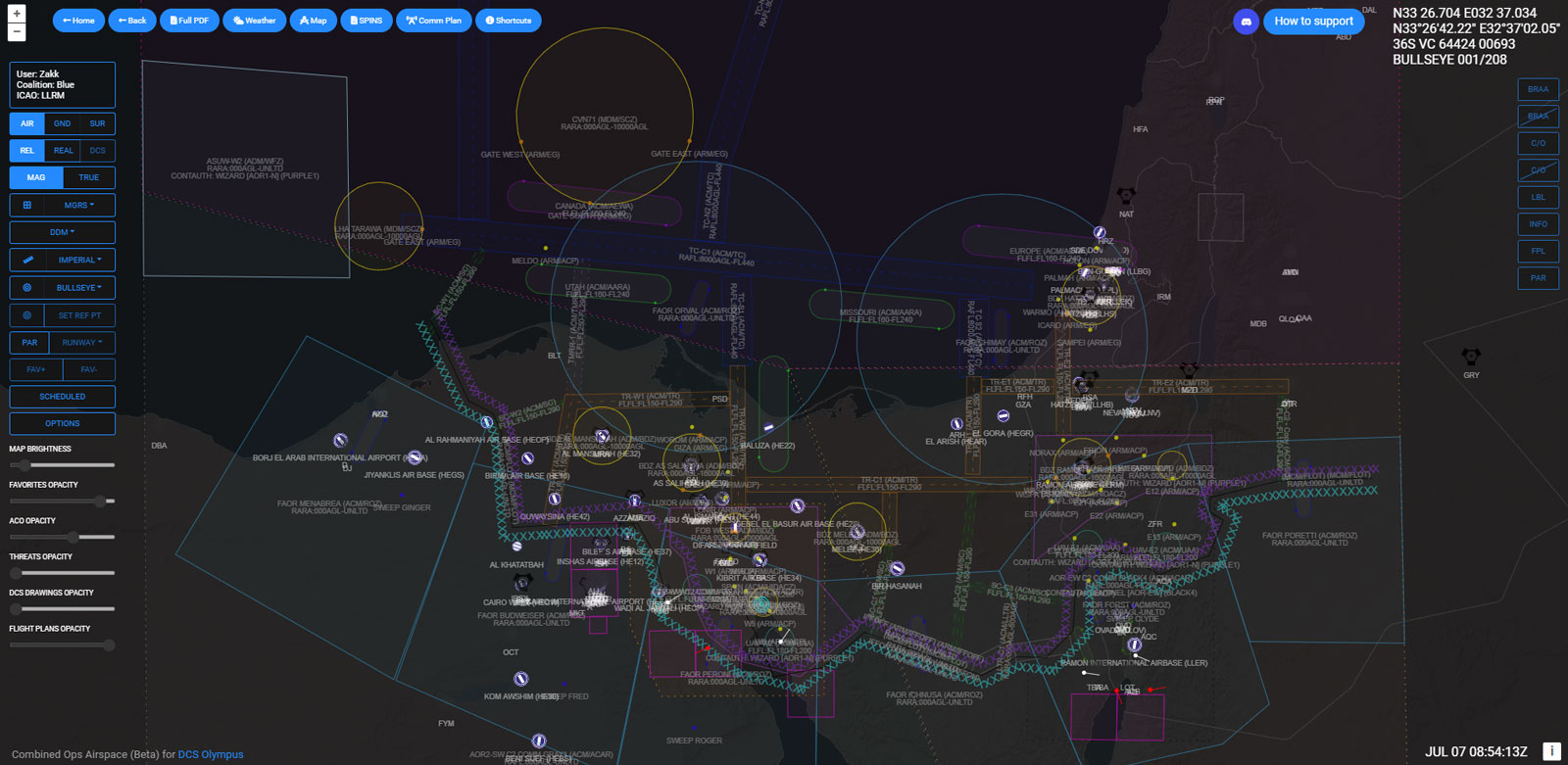
Interactive Radar and Airspace Map
The interactive map is the primary ATC, AWACS, and GCI control
interface for viewing and managing the DCS World airspace.
Users can switch between different map backgrounds, including
satellite imagery, an AWACS-style air picture, and native DCS World
terrain. The interface provides tools for measuring distance and
determining both true and magnetic bearings, while WGS84 and MGRS
grid overlays provide navigation and tactical references.
Individual map layers and overlays can be adjusted independently
to keep airspace, mission, and tactical information clearly visible.
Airspace Control Functions
DCS Airspace provides the core functions required for
AWACS and GCI control, allowing operators to maintain a live
tactical air picture, manage contacts and tracks, identify aircraft,
coordinate airspace, and control intercept operations.
The multi-controller architecture supports a shared tactical picture while
allowing individual operators to maintain their own areas of responsibility and tracks of interest.
Groups of Responsibility and Targeted Tracks can be shared between connected controllers with dedicated
tactical symbology, while Tracks of Interest remain operator-specific. This allows multiple ATC, AWACS, and GCI operators
to coordinate within the same live airspace environment without
losing their individual operational focus.
Advanced C2 capabilities extend the airspace-control workflow beyond
basic track display, including shared track management, mission data
integration, intercept geometry, ACO visualization, and
direct control of friendly IADS units.
AWACS and GCI Control Features
Multiple Bullseyes — switch between configured Bullseye
references during a mission for consistent tactical positioning
and reporting.
Identification system — identify tracks manually or through
automatic IFF Mode 4 interrogation. IFF Mode 3 codes are
automatically correlated with the Air Tasking Order (ATO), providing
mission data such as callsign and mission type. Once identified,
tracks remain identified even if the aircraft deactivates its IFF
or onboard systems, with dedicated hollow symbology distinguishing
persistent identification from active sensor detections.
BRAA — continuously calculate track-to-track bearing, range,
altitude, and aspect information or perform free-hand measurements
for tactical coordination.
Automated AWACS and GCI Picture Generation (Auto-Picture) — Automatically generate an AWACS/GCI
tactical air picture from a selected friendly reference aircraft by analyzing nearby unknown and hostile contacts.
The generated picture includes group count, relative position, bearing, range, altitude,
track, aspect and tactical amplifications such as closing, opening, echelon and
other group geometry. Supports both concise Core Information and detailed Traditional
picture formats for DCS World air intercept and air battle management.
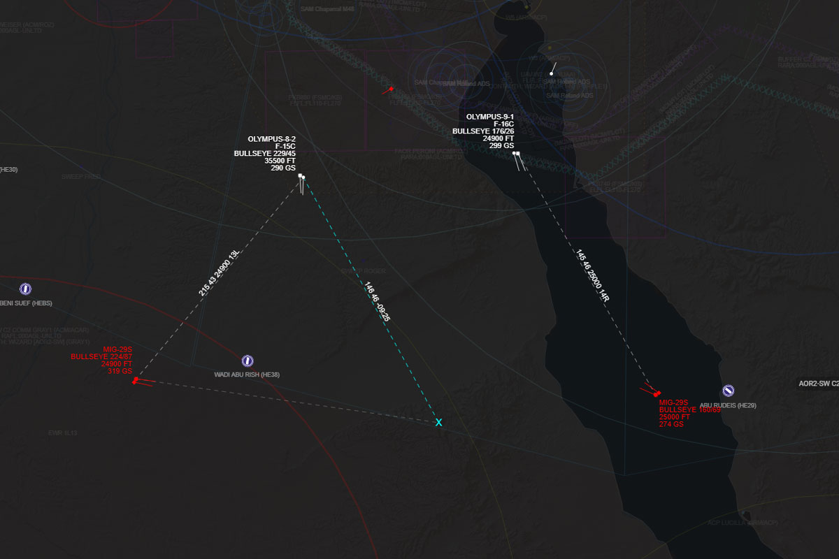
Intercept cut-off points — continuously calculate and display
track-to-track intercept geometry and cut-off information to support
tactical intercept planning.
Group of Responsibility — assign groups of contacts to an operator's
area of responsibility and share those assignments with other connected
controllers through dedicated tactical symbology.
Tracks of Interest — mark individual tracks for personal monitoring
without changing the shared tactical picture. Dedicated symbology keeps
operator-specific contacts clearly identifiable.
Targeted Tracks — designate tracks as operational targets and
share the designation with other connected controllers through
dedicated tactical symbology.
Flight and mission data — view active flights, flight plans,
and mission information relevant to the current tactical air picture.
ACO layers — display and customize Airspace Control Order
layers according to mission requirements, keeping established
airspace measures visible alongside the live tactical picture.
Threat circles — display known or detected threat areas
directly on the tactical map for airspace awareness and engagement
planning.
IADS control — directly control friendly IADS units from
the tactical map, including activating or deactivating SAM batteries
during the mission.
Contact filters — filter contacts by altitude, speed, and type
while preserving the visibility of Tracks of Interest and Groups
of Responsibility through dedicated symbology.
Visual and audio alerts — receive visual and audible
notifications for new contacts and other relevant mission events
requiring operator attention.
DCS-native sensor detection — use the detection state
reported directly by DCS World rather than replacing the simulation's
sensor-detection logic with an independent external radar model.
The controller therefore sees the sensor picture generated by the
DCS simulation itself, preserving fidelity to what each DCS sensor
or unit has actually detected. This is a fundamental part of the
realism of DCS Airspace: the tactical picture follows the
simulation state of DCS World rather than an independent
real-world radar model.
Extensive keyboard shortcuts — use dedicated keyboard shortcuts
for the main tactical and interface functions, enabling rapid access to
essential controls, reducing mouse interaction, and supporting efficient
operation during high-workload ATC, AWACS, and GCI scenarios.
REALISM & DCS WORLD DATA ACCURACY
A shared technical foundation that gives ATC, AWACS and GCI operators accurate DCS World terrain, simulation and sensor data for real-time radar operations, detection, identification, airspace control and tactical coordination.
DCS-NATIVE DETECTION DATA
Uses the sensor detection state reported directly by DCS World as the authoritative source for the live tactical picture. DCS Airspace does not replace the simulation with an independent radar-detection model: it presents and manages the contacts that DCS World determines its sensors and units can detect, preserving native simulation fidelity for ATC, AWACS and GCI operations.
DCS-NATIVE SRTM1 TERRAIN DATA
Uses high-fidelity SRTM1 elevation data from the actual DCS theater for terrain elevation, line-of-sight and terrain-masking analysis, keeping geographic calculations aligned with the simulated environment used by controllers and tactical operators.
REAL-TIME RADAR LOS
Provides terrain-based line-of-sight analysis using DCS World terrain data to support radar, sensor and tactical airspace assessment. The analysis complements the live sensor picture provided by DCS World rather than replacing its detection logic.
POINT-TO-POINT LOS ANALYSIS
Allows controllers and tactical operators to analyze line of sight between arbitrary locations and elevations for radar, sensor and airspace assessment using DCS-native terrain data.
TERRAIN MASKING ANALYSIS
Helps controllers assess how DCS World terrain affects radar and sensor visibility, supporting tactical interpretation of terrain masking across the operational area.
MISSION-DATE MAGNETIC VARIATION
Keeps tactical headings and bearings consistent with the magnetic variation applicable to the mission date, supporting accurate radar-control and airspace operations.
NATIVE DCS MAPS
Provides controllers with native DCS World map and theater references that correspond directly to the simulated operational environment, including airport diagrams for detailed airfield and ground-control operations.
ATC / GCI / AWACS RADAR DISPLAY
Provides an ATC, AWACS and GCI-oriented radar display designed for real-time air traffic control, tactical airspace management, contact monitoring, identification and air battle management within DCS World.
CUSTOMIZABLE TACTICAL DISPLAY
Provides a configurable tactical radar display with independent visibility and opacity controls for ACO, drawings, airbases, threat circles and other operational overlays, allowing controllers to keep the live air picture focused on the information required for ATC, AWACS and GCI operations.
UTM-CALIBRATED DATA
Maintains coordinate and geographic consistency between the tactical radar display, airspace calculations and the active DCS World theater.
Detection Realism Through DCS World Simulation Fidelity
For contact detection, realism means fidelity to the DCS World simulation.
Instead of replacing DCS World's sensor and detection logic with an independent external radar model,
DCS Airspace uses the detection state generated directly by DCS World and presents that information
through a dedicated controller workstation.
This approach keeps the controller's tactical picture consistent with the simulation itself.
Detection, sensor availability, terrain effects, aircraft state, and other mission conditions remain
those produced by DCS World, while DCS Airspace provides the tools required to interpret,
identify, manage, and control the resulting air picture.
The result is a realistic ATC, AWACS, and GCI environment within the DCS World simulation:
the system does not attempt to model a separate real-world environment alongside DCS World,
but instead builds the controller's operational experience around the data and behaviour of the simulation.
ATC Functions
DCS Airspace provides a dedicated ATC workstation for DCS World,
supporting airfield traffic management, ground movement, departures,
arrivals, flight coordination, and precision approaches within the same
real-time operational interface used for the wider airspace picture.
DCS Airspace is the live operational control component of Combined Ops,
used during DCS World missions by ATC, GCI and AWACS operators. It is not a
mission-planning tool: DCS AOC Tools and DCS Mission Planner
handle mission planning and preparation, while DCS Airspace provides the
real-time airspace-control workstation used during the mission.
Airfield ground visualization — monitor aircraft and ground
vehicles operating on runways, taxiways, and other airfield areas.
Takeoff and landing monitoring — track aircraft throughout
departure, approach, landing, and other airfield traffic operations.
Flight schedules — view scheduled flights together with
their associated mission information to support traffic coordination.
Flight plans — access flight plan information while
coordinating aircraft movements and airspace activity.
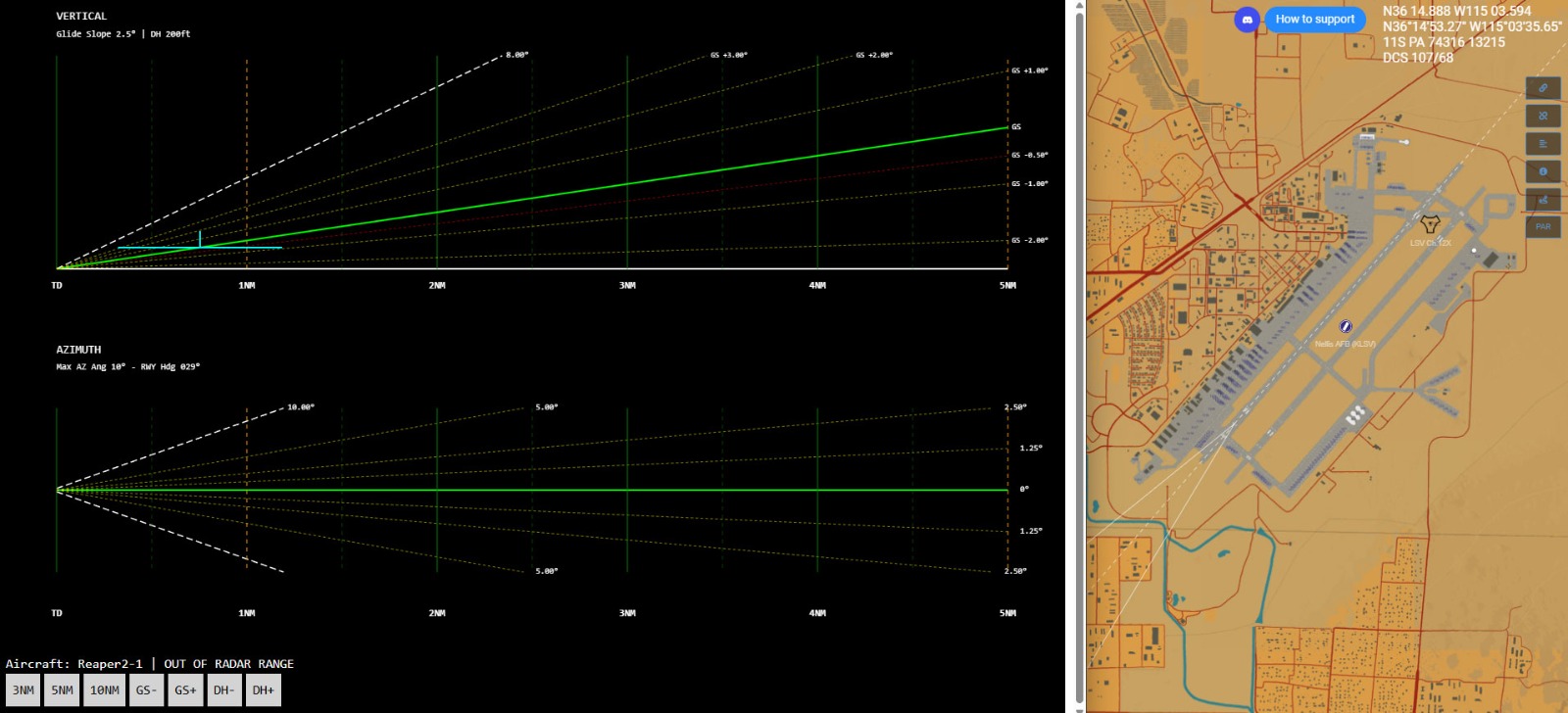
Precision Approach Radar (PAR) — use the dedicated PAR
display to support precision approaches, including operations
in IMC conditions.
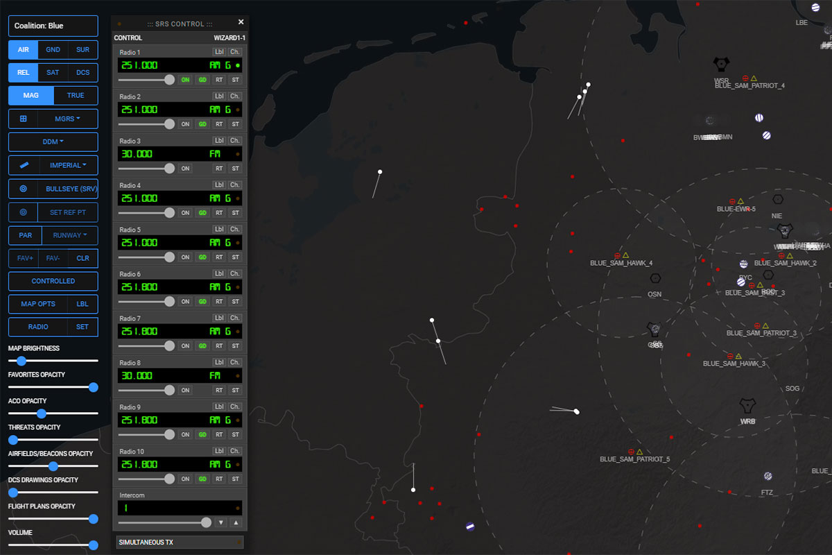
SRS Control Panel
DCS Airspace includes native Simple Radio Standalone (SRS)
integration through a dedicated control panel within the main
interface, allowing controllers to manage mission communications
without leaving the airspace workstation.
Live SRS control — interact with the connected SRS client
directly from DCS Airspace.
Frequency management — view and change active radio
frequencies from the integrated control panel.
Comm Plan integration — use the mission's active
Communication Plan to access configured frequencies and tune
the SRS client directly from the relevant operational assignments.
Combined Ops and its tools (DCS AOC Tools, DCS Mission Planner and DCS Airspace) are developed and maintained solely and exclusively for DCS World as a platform for digital entertainment and flight simulation. Our operations are strictly non-commercial and non-military. Under no circumstances is our environment intended, nor should it be used, for commercial purposes, professional pilot training, or any military applications. We are a community of enthusiasts dedicated to the hobby of flight simulation, and all our activities are conducted purely for recreational and educational enjoyment within the gaming community.